

>>>  x = 1
>>>  y = 4
>>>  x * y
4
>>>  x + y
5
>>>  x = [1, 2, 3]
>>>  y = 3 + x
Traceback (most recent call last):
  File "<console>", line 1, in <module>
TypeError: unsupported operand type(s) for +: 'int' and 'list'
>>>  x = [1, 2, 3]
>>>  y = [3 + z for z in x]
>>>  y
[4, 5, 6]
>>>  def poly(x, a, b, c):
...    y = [a * z**2 + b * z + c for z in x]
...    return y
...>>> poly([1,2,3], 2,-1,3)
[4, 9, 18]
>>>
>>> poly([1,2,3], a=2, b=-1, c=3)
[4, 9, 18]
>>>
>>> poly([1,2,3], c=2, b=-1, 3)
File "<console>", line 1
SyntaxError: non-keyword arg after keyword arg
>>>
>>> poly([1,2,3], 2, b=-1, c=3)
[4, 9, 18]
>>>  def foo(myparameter=99):
...     return myparameter*2
...
>>>  foo()
198
>>>  foo(100)
200
>>>  foo(myp=100)
Traceback (most recent call last):
  File "<console>", line 1, in <module>
TypeError: foo() got an unexpected keyword argument 'myp'
>>>  foo(myparameter=100)
200
>>>  foo(myparameterandabit=100)
Traceback (most recent call last):
  File "<console>", line 1, in <module>
TypeError: foo() got an unexpected keyword argument 'myparameterandabit'
for
loops
>>>  word = ["B", "A", "R", "R", "Y"]
>>>  for letter in word:
...     print letter
...
B
A
R
R
Y
>>>  n = len(word)
>>>  for ia in range(0,n):
...    a = word[ia]
...    for ib in range(ia+1, n):
...      b = word[ib]
...      print a,b
...
B A
B R
B R
B Y
A R
A R
A Y
R R
R Y
R Y
That's a fairly common pattern, we've cluttered it up. All we really want to do is:
for (a,b) in pairs(word):
  print a,b
>>>  def pairs(v):
...      n = len(v)
...      for i in range(0,n):
...          a = v[i]
...          for j in range(i+1, n):
...              b=v[j]
...              yield (a,b)
...
>>>  for (a,b) in pairs(word):
...    print a,b
...
B A
B R
B R
B Y
A R
A R
A Y
R R
R Y
R Y
#
# this is samples.py in my working directory
#
def bar(x):
  return x*2

def baz(x):
  return x*3
>>>  import samples
>>>  samples.bar(99)
198
>>>
>>>  from samples import baz
>>>  baz(100)
300
>>>
>>>  # if I edit samples.py....
>>>
>>>  reload(samples)
<module 'samples' from '/home/rowlings/Work/Teaching/GeostatSummerSchool/2014/Site/geostat/samples.pyc'>
>>>  import os
>>>  os.path.realpath(".")
'/home/rowlings/Work/Teaching/GeostatSummerSchool/2014/Site/geostat'
>>>  os.path.join("foo","bar","baz")
'foo/bar/baz'
>>>  os.uname()
('Linux', 'barry-OptiPlex-755', '3.8.0-31-generic', '#46-Ubuntu SMP Tue Sep 10 20:03:44 UTC 2013', 'x86_64')
Python comes with a complete standard library. R didn't have a full file name
handling package until 2014 (the
pathological
package on github).
>>>  help(os.uname)
Help on built-in function uname in module posix:

uname(...)
    uname() -> (sysname, nodename, release, version, machine)

    Return a tuple identifying the current operating system.
Unlike R, you can get help from objects!
>>>  x="hello world"
>>>  dir(x)
['__add__', '__class__', '__contains__', '__delattr__', '__doc__', '__eq__', '__format__', '__ge__', '__getattribute__', '__getitem__', '__getnewargs__', '__getslice__', '__gt__', '__hash__', '__init__', '__le__', '__len__', '__lt__', '__mod__', '__mul__', '__ne__', '__new__', '__reduce__', '__reduce_ex__', '__repr__', '__rmod__', '__rmul__', '__setattr__', '__sizeof__', '__str__', '__subclasshook__', '_formatter_field_name_split', '_formatter_parser', 'capitalize', 'center', 'count', 'decode', 'encode', 'endswith', 'expandtabs', 'find', 'format', 'index', 'isalnum', 'isalpha', 'isdigit', 'islower', 'isspace', 'istitle', 'isupper', 'join', 'ljust', 'lower', 'lstrip', 'partition', 'replace', 'rfind', 'rindex', 'rjust', 'rpartition', 'rsplit', 'rstrip', 'split', 'splitlines', 'startswith', 'strip', 'swapcase', 'title', 'translate', 'upper', 'zfill']
>>>  x.title()
'Hello World'
>>>  x.upper()
'HELLO WORLD'
>>>  x.split()
['hello', 'world']
>>>  help(x.split)
Help on built-in function split:

split(...)
    S.split([sep [,maxsplit]]) -> list of strings

    Return a list of the words in the string S, using sep as the
    delimiter string.  If maxsplit is given, at most maxsplit
    splits are done. If sep is not specified or is None, any
    whitespace string is a separator and empty strings are removed
    from the result.
x = "hello world"
creates an object
x
x.split()
runs the
split
"method" on
x
, returns a list.
x
doesn't change...
>>>  z = [9,6,2,3]
>>>  z.sort()
>>>  z
[2, 3, 6, 9]
>>>  last = z.pop()
>>>  last
9
>>>  z
[2, 3, 6]
>>>  class Point(object):
...    def __init__(self,x,y):
...      self.x = x
...      self.y = y
...    def coord(self):
...      return [self.x, self.y]
...    def shift(self, dx, dy):
...      self.x = self.x + dx
...      self.y = self.y + dy
...
>>>  p = Point(2.4, 4.5)
>>>
>>>  p.x
2.4
>>>
>>>  p.coord()
[2.4, 4.5]
>>>
>>>  p.shift(1000,2000)
>>>  p.coord()
[1002.4, 2004.5]
>>>
>>>  import math
>>>  def pythagoras(p0, p1):
...     return math.sqrt((p1.x-p0.x)**2 + (p1.y-p0.y)**2)
...
>>>  pythagoras(Point(0,0),Point(3,4))
5.0
>>>  # From: https://gist.github.com/gabesmed/1826175
>>>
>>>  EARTH_RADIUS = 6378137 # radius in metres
>>>
>>>  points = [
...             Point(40.750307,-73.994819),
...             Point(40.749641,-73.99527)
...           ]
>>>
>>>  def great_circle_distance(latlong_a, latlong_b):
...      lat1, lon1 = latlong_a.coord()
...      lat2, lon2 = latlong_b.coord()
...
...      dLat = math.radians(lat2 - lat1)
...      dLon = math.radians(lon2 - lon1)
...      a = (math.sin(dLat / 2) * math.sin(dLat / 2) +
...              math.cos(math.radians(lat1)) * math.cos(math.radians(lat2)) *
...              math.sin(dLon / 2) * math.sin(dLon / 2))
...      c = 2 * math.atan2(math.sqrt(a), math.sqrt(1 - a))
...      d = EARTH_RADIUS * c
...
...      return d
...
>>>  great_circle_distance(points[0], points[1])
83.32536285505579
Part one...
>>>  import numpy as np
>>>  [math.sin(x) for x in [1,2,3]]
[0.8414709848078965, 0.9092974268256817, 0.1411200080598672]
>>>  np.sin([1,2,3])
array([ 0.84147098,  0.90929743,  0.14112001])
>>>  np.random.poisson(10,20)
array([11, 12, 10,  8, 13, 11, 14, 10, 10, 13,  7, 15,  8, 12, 10, 10,  8,
        6, 11, 11])
>>>  m = np.matrix([[1,2], [3,4]])
>>>  m
matrix([[1, 2],
        [3, 4]])
>>>  m * m
matrix([[ 7, 10],
        [15, 22]])
>>>  m * m.transpose()
matrix([[ 5, 11],
        [11, 25]])
>>>  m * m.I
matrix([[  1.00000000e+00,   0.00000000e+00],
        [  8.88178420e-16,   1.00000000e+00]])
>>>  import geopy
>>>  from geopy.distance import great_circle
>>>
>>>  d = great_circle(points[0].coord(), points[1].coord())
>>>  d
Distance(0.0832555738102)
>>>  help(d)
Help on great_circle in module geopy.distance object:

class great_circle(Distance)
 |  Use spherical geometry to calculate the surface distance between two
 |  geodesic points. This formula can be written many different ways,
 |  including just the use of the spherical law of cosines or the haversine
 |  formula.
 |
 |  Set which radius of the earth to use by specifying a 'radius' keyword
 |  argument. It must be in kilometers. The default is to use the module
 |  constant `EARTH_RADIUS`, which uses the average great-circle radius.
 |
 |  Example::
 |
 |      >>> from geopy.distance import great_circle
 |      >>> newport_ri = (41.49008, -71.312796)
 |      >>> cleveland_oh = (41.499498, -81.695391)
 |      >>> great_circle(newport_ri, cleveland_oh).miles
 |      537.1485284062816
 |
 |  Method resolution order:
 |      great_circle
 |      Distance
 |      __builtin__.object
 |
 |  Methods defined here:
 |
 |  __init__(self, *args, **kwargs)
 |
 |  destination(self, point, bearing, distance=None)
 |      TODO docs.
 |
 |  measure(self, a, b)
 |
 |  ----------------------------------------------------------------------
 |  Methods inherited from Distance:
 |
 |  __abs__(self)
 |
 |  __add__(self, other)
 |
 |  __bool__ = __nonzero__(self)
 |
 |  __cmp__(self, other)
 |
 |  __div__(self, other)
 |
 |  __mul__(self, other)
 |
 |  __neg__(self)
 |
 |  __nonzero__(self)
 |
 |  __repr__(self)
 |
 |  __str__(self)
 |
 |  __sub__(self, other)
 |
 |  __truediv__ = __div__(self, other)
 |
 |  ----------------------------------------------------------------------
 |  Data descriptors inherited from Distance:
 |
 |  __dict__
 |      dictionary for instance variables (if defined)
 |
 |  __weakref__
 |      list of weak references to the object (if defined)
 |
 |  feet
 |
 |  ft
 |
 |  kilometers
 |
 |  km
 |
 |  m
 |
 |  meters
 |
 |  mi
 |
 |  miles
 |
 |  nautical
 |
 |  nm

>>>
>>>  d.meters
83.255573810242
>>>
>>>  d.feet
273.1482079345222
>>>
>>>  geopy.distance.EARTH_RADIUS = EARTH_RADIUS/1000
>>>  great_circle(points[0].coord(), points[1].coord()).meters
83.32357305730429
>>>  from geopy.distance import vincenty
>>>  great_circle(points[0].coord(), points[1].coord()).m
83.32357305730429
>>>  vincenty(points[0].coord(), points[1].coord()).m
83.19003856394464
>>>  from geopy.geocoders import osm
>>>  g = osm.Nominatim(timeout=10)
>>>  home = g.geocode("Lancaster, UK")
>>>  away = g.geocode("Bergen")
>>>  vincenty(home.point, away.point).miles
532.7862059372253
>>>  vincenty(home.point, away.point).km
857.4362841353374
>>>  import fiona
>>>  england = fiona.open("./data/England/engos.shp","r")
>>>  england.meta
{'crs': {u'lon_0': -2, u'k': 0.9996012717, u'datum': u'OSGB36', u'y_0': -100000, u'no_defs': True, u'proj': u'tmerc', u'x_0': 400000, u'units': u'm', u'lat_0': 49}, 'driver': u'ESRI Shapefile', 'schema': {'geometry': 'Polygon', 'properties': OrderedDict([(u'ADMIN_NAME', 'str:16'), (u'AREA', 'float:12.3'), (u'PERIMETER', 'float:12.3'), (u'ADMIN2_', 'float:11'), (u'ADMIN2_ID', 'float:11'), (u'GMI_ADMIN2', 'str:16'), (u'COUNTRY', 'str:16')])}}
>>>  england.meta['crs']
{u'lon_0': -2, u'k': 0.9996012717, u'datum': u'OSGB36', u'y_0': -100000, u'no_defs': True, u'proj': u'tmerc', u'x_0': 400000, u'units': u'm', u'lat_0': 49}
>>>  england.meta['schema']['properties']
OrderedDict([(u'ADMIN_NAME', 'str:16'), (u'AREA', 'float:12.3'), (u'PERIMETER', 'float:12.3'), (u'ADMIN2_', 'float:11'), (u'ADMIN2_ID', 'float:11'), (u'GMI_ADMIN2', 'str:16'), (u'COUNTRY', 'str:16')])
>>>  features = list(england)
>>>  features[31]['properties']
OrderedDict([(u'ADMIN_NAME', u'Greater London'), (u'AREA', 0.208), (u'PERIMETER', 2.344), (u'ADMIN2_', 68.0), (u'ADMIN2_ID', 68.0), (u'GMI_ADMIN2', u'GBR-ENG-GLN'), (u'COUNTRY', u'England')])
>>>  features[32]['geometry'].keys()
['type', 'coordinates']
>>>  features[32]['geometry']['type']
'Polygon'
>>>  features[32]['geometry']['coordinates'][0][:10]
[(331218.2373748748, 158030.96091701294), (331552.45641719806, 159850.56801485896), (331184.5610176229, 161275.67909807622), (332744.8749578969, 162213.8018719227), (333147.93532494607, 163443.23593871036), (333276.9293876288, 164430.18301096238), (332605.5811962088, 164841.68800689976), (332557.7609554768, 165614.56502538442), (333861.26445889025, 166247.08819716435), (335210.2781934715, 165920.42688398046)]
>>>  from shapely.geometry import mapping, shape
>>>
>>>  import fiona
>>>
>>>  input_shp = "./data/England/engos.shp"
>>>  output_shp = "./data/England/buffered.shp"
>>>  width = 10000
>>>
>>>  def bufferinout(input_shp, output_shp, width):
...      input = fiona.open(input_shp, "r")
...      schema = { 'geometry': 'Polygon', 'properties': { 'name': 'str' } }
...      output =  fiona.open(output_shp, "w", "ESRI Shapefile", schema, crs = input.crs)
...      for feature in input:
...           output.write({
...           'properties': {
...               'name': feature['properties']['ADMIN_NAME']
...           },
...           'geometry': mapping(shape(feature['geometry']).buffer(width))
...           })
...
>>>  bufferinout(input_shp, output_shp, width)
With this in
buffering.py
for example:
import sys

import fiona

def bufferinout(input, output, width):
  " compute the buffer... "
  ....

if __name__=="__main__":
  input = sys.argv[1]
  output = sys.argv[2]
  width = float(sys.argv[3])
  bufferinout(input, output, width)
Can then:
python buffering.py england.shp buffer10k.shp 10000
on the command line
from buffering import bufferinout
in python and use that function.
for width in 10000 20000 30000 40000 ; do
 python buffering.py england.shp buffer${width}.shp $width
done
Or in Python:
from buffering import bufferinout
for width in [10000, 20000, 30000, 40000]:
     bufferinout("england.shp","buffer%s.shp" % width, width)

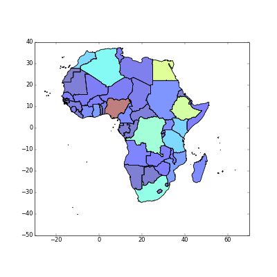
>>>  import geopandas as gpd
>>>  africa = gpd.read_file("./data/Africa/africa.shp")
>>>  africa[:5]
     CNTRY_NAME  COUNT FIRST_CONT FIRST_FIPS       FIRST_REGI  SUM_POP_AD  \
0       Algeria     48     Africa         AG  Northern Africa    34222570
1        Angola     18     Africa         AO    Middle Africa    11527258
2         Benin      6     Africa         BN   Western Africa     5175394
3      Botswana     10     Africa         BC  Southern Africa     1185250
4  Burkina Faso     30     Africa         UV   Western Africa    10817069

    SUM_SQKM_A  SUM_SQMI_A                                           geometry
0  2320972.339  896127.445  POLYGON ((2.963609933853149 36.80221557617188,...
1  1252420.770  483559.643  (POLYGON ((11.77499961853027 -16.8047256469726...
2   116514.769   44986.354  POLYGON ((2.484417915344238 6.340485572814941,...
3   580011.123  223942.302  POLYGON ((26.16782760620117 -24.66396713256836...
4   273719.207  105682.987  POLYGON ((-1.003023386001587 14.8400993347168,...

[5 rows x 9 columns]
>>> import matplotlib.pyplot as plt
>>> fig = africa.plot(column="SUM_POP_AD")
>>> plt.show()
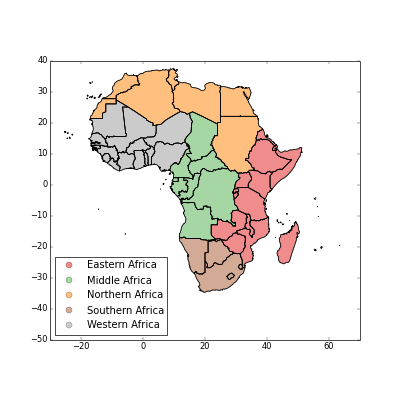
>>> plt.cla()
>>> fig = africa.plot(column="FIRST_REGI",legend=True)
>>> plt.show()
>>> from geopandas import GeoSeries
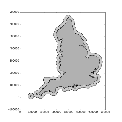
>>> england = gpd.read_file("./data/England/engos.shp")
>>> fig = england.plot()
>>> plt.show()
>>> plt.cla()
>>> coast = GeoSeries(england.geometry.unary_union)
>>> coastal_buffer = GeoSeries(coast.buffer(20000))
>>> fig = coastal_buffer.plot()
>>> fig = coast.plot()
>>> plt.show()

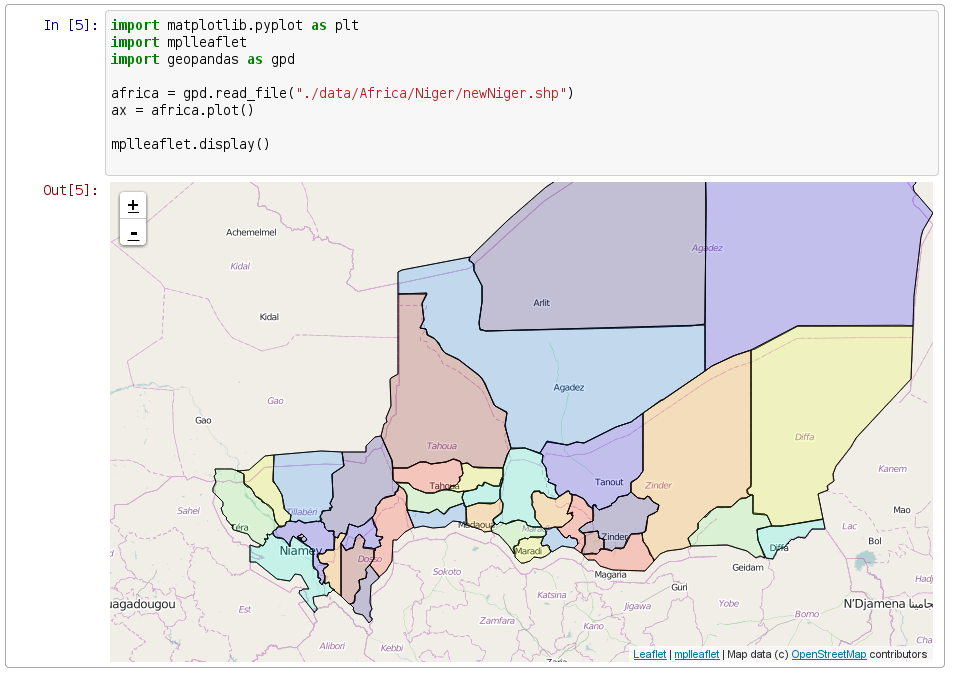
import mplleaflet
niger = gpd.read_file("./data/Africa/niger.shp")
niger.plot()
# write an HTML file and show in browser
mplleaflet.show()
# convert to geoJSON file
open("niger.json","w").write(niger.to_json())
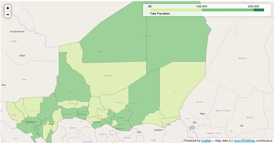
map_osm = folium.Map(location=[17,10])
# add map to output
map_osm.geo_json("./niger.json", data=niger,
columns=['ADM2','POP'], key_on='feature.properties.ADM2',
fill_color='YlGn', fill_opacity=0.7, line_opacity=0.2,
legend_name="Fake Population")
# create and view in browser
map_osm.create_map("niger.html")
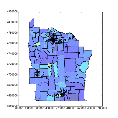
>>>  import geopandas as gpd
>>>  import numpy as np
>>>  import pysal
>>>  shapefile = "data/NewYork/NY8_utm18.shp"
>>>  galfile = "data/NewYork/NY_nb.gal"
>>>  spdf = gpd.read_file(shapefile)
>>>
>>>  y = np.array(spdf['Cases'])
>>>  w = pysal.open(galfile).read()
>>>  lm = pysal.Moran_Local(y,w,transformation="V")
>>>  lm.Is[:5]
array([ 0.56778845,  0.70374966, -0.51771761, -0.19487455, -0.17114584])
>>>  spdf['I']=lm.Is
>>>  spdf.plot(column="I")
<matplotlib.axes.AxesSubplot object at 0x60dbc10>
>>>  plt.show()
>>> import rpy2.robjects as robjects
>>> from rpy2.robjects.packages import importr
>>> spdep = importr("spdep")
>>> NY_nb = spdep.read_gal(galfile, region=range(281))
>>> lmR = spdep.localmoran(robjects.FloatVector(spdf['Cases']), listw = spdep.nb2listw(NY_nb, style="S"))
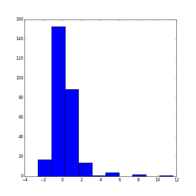
>>> fig = plt.hist(lmR.rx(True,"Z.Ii"))
>>> plt.show()